


Pittsburgh Weather Update: Relief From Heat Wave as Storms Bring Cooler Temperatures
After enduring five consecutive days of 90°F+ temperatures, Pittsburgh is finally getting some relief as a cooling trend begins today, with highs expected to stay in the 80s thanks to increased storm chances. However, the break from extreme heat comes with the risk of pop-up thunderstorms, some of which could turn severe.
Today’s Forecast: Storms Return, Temperatures Dip
- 🌡️ Highs: Mid-to-upper 80s (cooler than recent 90s)
- 🌧️ Rain Chances: Scattered storms likely in the afternoon
- 💨 Winds: Light, from the south
- 🌙 Overnight Lows: Low 70s (6th straight night above 70°F)
Why Are Storms Popping Up?
Meteorologists are tracking “outflow boundaries”—ripples in the atmosphere that act like mini cold fronts, forcing warm, humid air to rise rapidly. When this unstable air breaks through a capping layer of stable air above it, storms explode.
- ⚡ Severe Potential: Some storms could produce heavy downpours, gusty winds, and lightning.
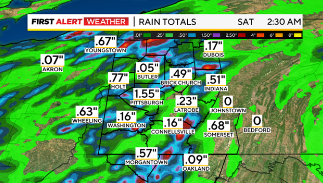
- 🌊 Flood Risk: The ground is already saturated, increasing the chance of localized flash flooding.
Weekend Outlook: More Storms, Finally Cooler Nights
Saturday:
- Another round of scattered storms expected
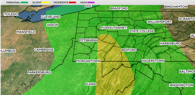
- Level 1/4 flash flood risk (may increase if today’s rain is heavy)
- Highs in the mid-to-upper 80s
Sunday:
- Cooler start—first sub-70°F morning in over a week
- Highs near 88°F, with lower humidity
Next Week: Mid-80s Dominate, More Storm Chances
- Monday: Another storm system moves in, keeping highs in the mid-80s.
- Tuesday-Thursday: Drier, but still warm (mid-80s) with isolated rain chances.